case - TLN zet kaartviewer in Amsterdam

Complex decision-making regarding zero-emission zone calls for a clear starting point

Emission-free supply of our city centres is the future. But how do local authorities set the boundaries of these zero-emission zones? This is a complex challenge in which the industry association for transport and logistics (Transport en Logistiek Nederland) is assuming its responsibility. TLN and Geodan have developed a map viewer that provides data on the local situation, and in so doing supports the decision-making process.

Quick answers

Anticipating the European legislation, the Dutch climate agreement provides that only emission-free vehicles will be allowed in city centres from 2025. This is the only way that CO2, NOx and particulate matter emissions resulting from urban freight logistics can be reduced to nil. This is very important for the transport and logistics sector, in other words, in order to find quick answers to questions regarding the zero-emission zone. While this is the responsibility of local governments, various stakeholders are involved in the decision-making process. Industry association TLN is one of the negotiation partners, and would like to identify the location and impact of the implementation of this for its members at the earliest possible stage. Retailers, wholesale companies and transport companies can then base their plans on these developments accordingly.

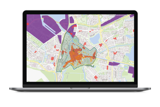
For a long time, urban freight logistics was discussed with local authorities based on printed maps and print screens. However, the complexity of this challenge and the assessment of so many different interests call for a different, smarter set of procedures. Cooperation with supply chain partners and other partners play a key role in the ambition set to supply city centres without generating any emissions by 2025. This cooperation starts with a single and shared picture of the local situation among all stakeholders. This requires that a large amount of specific data be collected and aggregated.

SOLUTION

Reaching a sensible solution together

In order to establish one of these zones and incorporate local variables, it was important to collect, analyse, integrate and visualise large amounts of specific data across high-population areas (which double as low-traffic areas), historical city centres, shopping centres, environmental areas, business parks and ring roads. Geodan aggregated all this open data. By combining several layers of maps, we can highlight the boundaries with greater accuracy. Having access to the specific information required and a shared picture of the situation at the local authority and other stakeholders is one of the prerequisites for a good discussion. Together, they make the most sensible decisions, using interactive means. The map viewer provides specific guidelines and insights when making the correct assessments and choices in a complex decision-making process.

case - TLN Kaartviewer

Quick and clear insight: the map viewer shows the environmental zone (green), the shopping areas (red), the historical city centre (orange) and the business estates or potential hubs (purple).

Geodan translated a complex question into a tool which is easy and comprehensible. The map viewer provides us with a particularly useful and effective tool.

Anne-Marie Nelck (urban freight distribution expert, TLN)
THE RESULT

Clear and shared picture

‘Geodan’s map viewer has made the discussion around the zero-emission zone significantly easier’, says Anne-Marie Nelck, urban freight distribution expert at TLN. ‘The clear representation and the significant user-friendliness allows us to use the map viewer quickly and easily. We are working closely with local authorities. The people who represent our interests at the regional level are debating with local authorities about where the zero-emission zones should be located. We have been doing this since recently, using Geodan’s map viewer, in an interactive and innovative way. It’s a convenient tool that quickly gives you access to the information you need and ensures that discussions are based on factual arguments.’ At the same time, it also makes it possible to look beyond municipal boundaries. This enables you to assess a situation from a regional perspective, which is very valuable in light of the essential cooperation.