Kennis&innovatie Ruimtelijke data op het wereldwijde web

Spatial data on the web..?

It is a common statement that 80% of all data has a spatial component, making spatial data an indispensable ingredient of virtually every work and business process. With that in mind, it is important that spatial data can be published and shared easily.

Spatial data has been published on the Internet for over 20 years, though this was typically done with sector-specific geostandards, rather than the commonly known www standards. These geostandards can only be understood properly by geospecialists, restricting their usefulness for non-specialists (web developers) in the more general web community.

The web has brought drastic change to the world

In 1991, the world wide web (www) was invented by Tim Berners-Lee, now director of the W3C (World Wide Web Consortium). The web is based on technical standards, with the most important ones being HTTP, a protocol for the exchange of hypertext (text with hyperlinks), HTML, a standard format for the layout of hypertext, and URLs or URIs, universal resource identifiers.

The emergence of the web made it possible to publish and link text documents in a universal way. In addition to text, (silent or moving) images were later shared via web standards as well, and nowadays, web browsers can do so much that they can be regarded as fully-fledged operating systems, such as Windows or Linux. That the web has had a huge impact on the world is almost an understatement. After all, worldwide communication has been through drastic social, economic, cultural and political changes. The web itself, however, is also changing.

From the semantic web to linked data

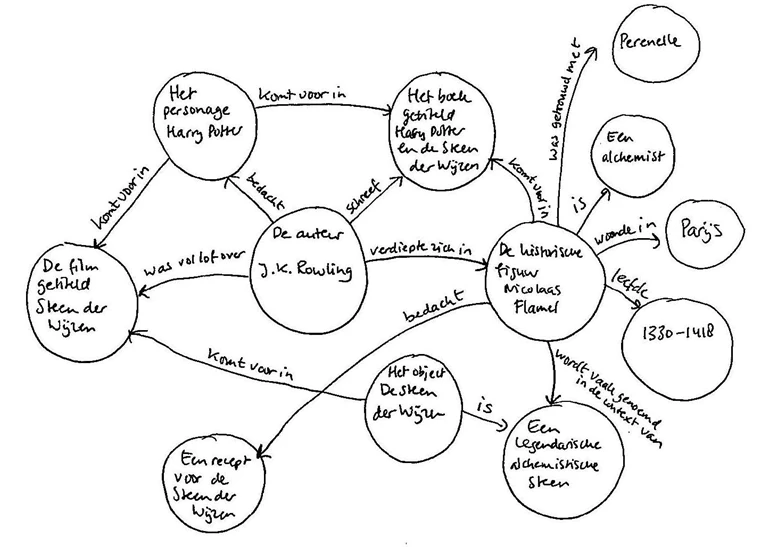
There is a growing tendency to use the web’s protocols for sharing raw data, which is a source of information and knowledge. It forms the foundation of many decisions made by companies, authorities, and citizens. Data-sharing happens on what is known as the semantic web, which goes beyond the current web that only links content pages to each other. In fact, the semantic web is a distributed database, in which data entities and objects can be identified with unique references, also known as URIs (Uniform Resource Identifiers). This leads to the creation of linked data.
In 2006, Tim Berners-Lee defined four principles for publishing linked data:
1. Use Uniform Resource Identifiers (URIs) as names for entities or objects.
2. Use HTTP(S) URIs so that people can look up those names on the web.
3. Publish usable information with standard protocols (RDF, SPARQL) when someone looks up a URI.
4. Include links to other URIs, so that people can discover more entities or objects.

Tim Berners-Lee also came up with a star system to show the usability of a given dataset. According to the linked data star rating, there are five degrees of openness for data sets. The more stars a dataset has, the higher its quality and greater its openness. The star system is used all over the world to encourage organizations to be as ‘open’ as possible.

Geo sector was way ahead of its time

In the absence of semantic web standards, which were not developed until 2006, the geosector developed a set of of almost 60 standards for publishing spatial data on the web, spearheaded by the Open Geospatial Consortium. Thanks to this historic development, spatial data are now published across the world, almost exclusively with geo-specific standards. The major drawback of this approach is that these sector-specific standards are only known to experts in the field, and that the standards are only supported by geographic information systems. Web developers without a background in geography typically cannot work with these specific geostandards and find them difficult to use when compared to ‘regular’ web standards.

Unique collaboration between W3C and OGC

The Open Geospatial Consortium (OGC) also recognizes this problem and has set on a new course by developing new standards, based on standard web protocols. The decision was made to abandon geo-specific protocols, in favor of implementing standard web technology, such as search engines, browsers, https, hyperlinks and open RESTful APIs.

In order to enable the free sharing of spatial data on the web, the Open Geospatial Consortium and the Word Wide Web Consortium set up a joint working group in 2014, the de Spatial Data on the Web Working Group (SDWWG). That was a unique occurrence; never before had the OGC and W3C worked together in this way.

The working group is committed to improving and clarifying standards for dealing with spatial data on the web. After identifying which standards and tools exist nowadays, and pinpointing how spatial data are currently published online, the working group will explore the extent to which current web-based data practices, such as search engines, browsers, HTTP(S), hyperlinks (URIs) and open RESTful APIs, can be applied to spatial data. To find out more about this working group, please visit the W3C website.

Spatial data on the web – how does it work in practice?

United under the banner of the SDI.Next initiative, Geonovum, Kadaster and other government organizations are trying to shape the process by which spatial data are published via standard web concepts. They explained their shared vision on the publication of spatial data via web protocols in greater detail in a Whitepaper on Geostandards (December 2017). On top of that, they have also run ample experiments with publishing spatial data in the PDOK data lab, along with Geodan.

In addition, the initiative has drawn up a draft API strategy and URI strategy in the context of the Environment and Planning Act, which also includes the publication of spatial data via linked data principles. The API strategy describes how consistent, uniform APIs can lead to an open, robust API system. The URI strategy ensures that all information included in the system can be found and accessed in a uniform, coherent manner. The URI strategy also includes clear guidelines on how URIs should be structured.

The Future is bright

The partnership between the OGC and W3C has brought the geo and web worlds one step closer together. The joint development of new standards for publishing spatial data on the basis of standard web protocols should be regarded as a key step in the continued evolution of geostandards that will benefit and boost the publication and use of spatial data on the web. This development is set to give a much wider community easy access to a wealth of spatial information.

> Read all of Frans Knibbe’s blogs about these interesting developments