Geomilieu breidt uit met geluidsdatamodel

Geomilieu set to expand with a sound data model

This summer, the Geomilieu tool will be expanded with a 3D data model in the field of sound. The model will be made available nationwide and has been made suitable specially for integration into the standard sound modeling software. Geodan and DGMR bundled their years of experience in the field of GIS and sound software for the realization of the model.

Mapping out noise pollution is important. We keep living closer to each other and houses are being built closer to roads and railways. The government is obliged to take sound-attenuating measures when and where standards are exceeded, such as installing sound barriers next to roads or providing sound insulation for houses.

Massive time savings

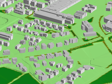
Geodan’s 3D data model offers massive time savings for environmental services, authorities, and consultants. Until recently, making noise levels transparent was still manual work, making it a time-consuming task. An important one, nonetheless, because noise pollution is a very common problem in society. The 3D data from the sound model match the data from the national Basic Registry of Addresses and Buildings (BAG), Basic Registry of Large-scale Topography (BGT) and Current Height Database The Netherlands (AHN).

Geomilieu

Starting from the summer of 2018, the 3D data for all of the Netherlands will be available in Geomilieu,the most popular software package used to perform DGMR sound studies. Geomilieu offers powerful tools for calculating, analyzing, and presenting the effect of environmentally damaging activities, such as noise, air quality and odor. The 3D data can be accessed directly in Geomilieu via an additional 3D data plan. This gives DGMR customers direct access to the latest 3D models.